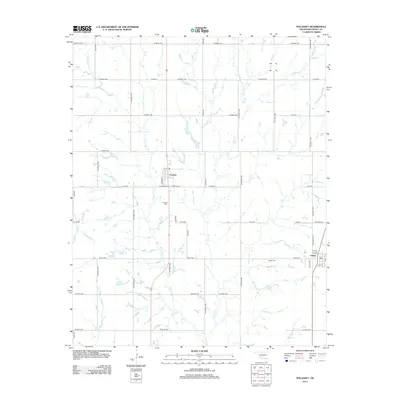
2012 Map of Pocasset
USGS Topo · Published 2012About this map
The agrarian landscape of Grady County centers on the rail-aligned community of Pocasset and the neighboring settlement of Amber. In this early 21st-century documentation, the region's layout is defined by a strictly surveyed grid of county roads, such as Co Road 1220 and Co Street 2820, which segment the rolling plains. Water is managed through the meandering paths of W Fork Salt Cr and Salt Cr, which cut through the agricultural sections. For those researching family history, the map precisely locates the Pocasset Cem just south of its namesake town and the Amber Cem further east. The transition from rural section lines to town streets like W Cardinal St and W Main St illustrates the development pattern of these small Oklahoma towns as they serve the surrounding farming community.
Find a feature on this map
44 named features on this map. Tap any name to fly to it.
Don’t see what you’re looking for? This feature index may not catch every label — zoom into the map to look around manually.
Map Details
Editions of this 2012 Pocasset Map
This is the sole edition of this map. No revisions or reprints were ever made.
Other maps of this area

1893 · Buggy Creek
USGS Topo · 1:62,500

1893 · Minco
USGS Topo · 1:62,500

1904 · Chickasha
USGS Topo · 1:125,000

1945 · Anadarko
USGS Topo · 1:62,500

1954 · Oklahoma City
USGS Topo · 1:250,000

1955 · Clinton
USGS Topo · 1:250,000

1957 · Clinton
USGS Topo · 1:250,000

1957 · Oklahoma City
USGS Topo · 1:250,000

1963 · Oklahoma City
USGS Topo · 1:250,000
1966 · Chickasha
USGS Topo · 1:24,000