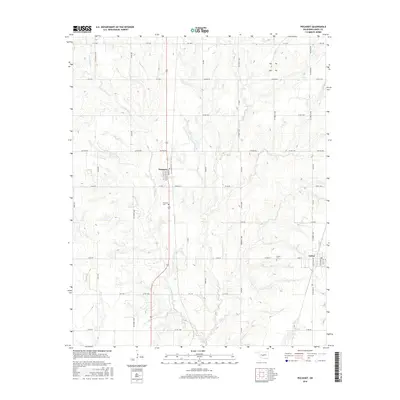
2016 Map of Pocasset
USGS Topo · Published 2016About this map
The agrarian landscapes of Grady County appear here in a recent survey of the region south of the Canadian River. The settlement of Pocasset serves as a central hub, organized along its primary corridors of Adams St, Washington St, and Main St. To the southeast, the town of Amber is situated at the junction of several section-line roads, providing a secondary center for this rural community. The area is defined by the drainage network of the W Fork Salt Cr and Salt Cr, which meander through a grid of numbered and named county roads. Genealogists can identify key local landmarks such as Pocasset Cem and Amber Cem, while the road system, including named routes like Sooner Rd and Dutton Rd, reflects the long-standing infrastructure that has supported Oklahoma's farming tradition into the 21st century.
Find a feature on this map
51 named features on this map. Tap any name to fly to it.
Don’t see what you’re looking for? This feature index may not catch every label — zoom into the map to look around manually.
Map Details
Editions of this 2016 Pocasset Map
This is the sole edition of this map. No revisions or reprints were ever made.
Other maps of this area

1893 · Buggy Creek
USGS Topo · 1:62,500

1893 · Minco
USGS Topo · 1:62,500

1904 · Chickasha
USGS Topo · 1:125,000

1945 · Anadarko
USGS Topo · 1:62,500

1954 · Oklahoma City
USGS Topo · 1:250,000

1955 · Clinton
USGS Topo · 1:250,000

1957 · Clinton
USGS Topo · 1:250,000

1957 · Oklahoma City
USGS Topo · 1:250,000

1963 · Oklahoma City
USGS Topo · 1:250,000
1966 · Chickasha
USGS Topo · 1:24,000