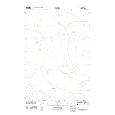
2011 Map of Pocochichee Butte
USGS Topo · Published 2011About this map
Pocochichee Butte rises as a prominent landmark in this section of Powder River County, where the high plains landscape is defined by an intricate network of seasonal drainages and named buttes. The map shows a region shaped by ranching and water management, evidenced by the presence of Pete Dam and numerous small stock reservoirs scattered across the terrain. Waterways such as Honeycomb Creek, Flag Creek, and Timber Creek carve paths through the dry landscape, converging toward the North Fork Dry Creek. The land is punctuated by distinct geological features including Hackett Butte and Saddle Butte, providing navigation points in a territory with few paved roads. Named draws like Plum Thicket Draw and W L Draw suggest a landscape where even subtle topography and vegetation variations were critical for local identification and land use.
Find a feature on this map
14 named features on this map. Tap any name to fly to it.
Don’t see what you’re looking for? This feature index may not catch every label — zoom into the map to look around manually.
Map Details
Editions of this 2011 Pocochichee Butte Map
This is the sole edition of this map. No revisions or reprints were ever made.
Other maps of this area

1954 · Ekalaka
USGS Topo · 1:250,000

1956 · Ekalaka
USGS Topo · 1:250,000

1958 · Ekalaka
USGS Topo · 1:250,000

1965 · Ekalaka
USGS Topo · 1:250,000

1979 · W L Butte
USGS Topo · 1:24,000

1979 · Rattlesnake Ridge
USGS Topo · 1:24,000

1979 · McKenzie Creek
USGS Topo · 1:24,000
1979 · Pocochichee Butte
USGS Topo · 1:24,000
1979 · Davis Creek West
USGS Topo · 1:24,000
1979 · Davis Creek East
USGS Topo · 1:24,000