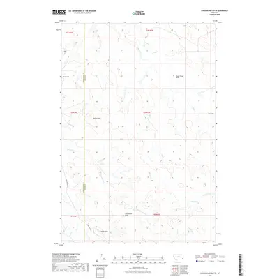
2020 Map of Pocochichee Butte
USGS Topo · Published 2020About this map
Pocochichee Butte rises from the high plains of Southeast Montana, anchoring a landscape defined by seasonal drainages and prominent geological landmarks. This 2020 topographic study illustrates the sparse, high-country character of the borderlands between Powder River and Carter Counties. The map details a network of named draws and creeks, such as Plum Thicket Draw and Pocochichee Cr, which carve through the terrain. Evidence of the region's erosion patterns is visible in features like the Honeycomb Hills and Mud Buttes. Human presence is minimal, primarily traced through the winding path of Crow Creek Rd and the straight boundaries of the Public Land Survey System. The map serves as a primary record for tracing the physical geography and land management divisions of this vast rangeland, where isolated landmarks like Hackett Butte and Saddle Butte served as essential navigational points for generations.
Find a feature on this map
23 named features on this map. Tap any name to fly to it.
Don’t see what you’re looking for? This feature index may not catch every label — zoom into the map to look around manually.
Map Details
Editions of this 2020 Pocochichee Butte Map
This is the sole edition of this map. No revisions or reprints were ever made.
Other maps of this area

1954 · Ekalaka
USGS Topo · 1:250,000

1956 · Ekalaka
USGS Topo · 1:250,000

1958 · Ekalaka
USGS Topo · 1:250,000

1965 · Ekalaka
USGS Topo · 1:250,000

1979 · W L Butte
USGS Topo · 1:24,000

1979 · Rattlesnake Ridge
USGS Topo · 1:24,000

1979 · McKenzie Creek
USGS Topo · 1:24,000
1979 · Pocochichee Butte
USGS Topo · 1:24,000
1979 · Davis Creek West
USGS Topo · 1:24,000
1979 · Davis Creek East
USGS Topo · 1:24,000