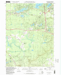
1997 Map of Pocono Pines
USGS Topo · Published 1998About this map
Lake Naomi and Stillwater Lake anchor a landscape defined by significant late-twentieth-century residential growth throughout the Monroe County highlands. The map reveals the expansion of planned communities like Lake Naomi Estates, Stillwater Lake Estates, and Pocono Summit Estates, which emerged around the area's numerous natural and man-made water bodies. This development pattern sits atop a much older industrial geography, evidenced by the Old Railroad Grade that cuts across the township lines of Tobyhanna and Coolbaugh.
Find a feature on this map
63 named features on this map. Tap any name to fly to it.
Don’t see what you’re looking for? This feature index may not catch every label — zoom into the map to look around manually.
Map Details
Editions of this 1997 Pocono Pines Map
This is the sole edition of this map. No revisions or reprints were ever made.
Other maps of this area

1914 · Wind Gap
USGS Topo · 1:62,500

1916 · Wind Gap
USGS Topo · 1:62,500

1919 · Pocono
USGS Topo · 1:62,500

1921 · Pocono
USGS Topo · 1:62,500

1922 · Mauch Chunk
USGS Topo · 1:62,500

1922 · Stoddartsville
USGS Topo · 1:62,500

1923 · Pocono
USGS Topo · 1:62,500

1924 · Stoddartsville
USGS Topo · 1:62,500

1924 · Mauch Chunk
USGS Topo · 1:62,500

1943 · Scranton
USGS Topo · 1:125,000
Featured Places
- Pocono Pines, Tobyhanna Township
- Pocono Pines, Tobyhanna Township
- Long Pond, Tunkhannock Township
- Chestnuthill Township, PA
- Tobyhanna Township, PA