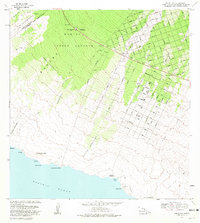
1981 Map of Pohue Bay
USGS Topo · Published 1981About this map
Manuka State Park and the expansive Manuka Forest Reserve dominate the upper elevations of this Hawaii Island landscape, where the rugged volcanic history of the South Kona and Kau Districts is on full display. The map reveals the stark path of the Lava Flow of 1907 and the Lava Flow of 1887 as they cut through older vegetation. This 1980s-era survey documents a period of significant transition, capturing the grid of the Hawaiian Ocean View development, including streets like King Kamehameha Blvd and Aloha Blvd, emerging alongside ancient sites. Along the coastline at Pohue Bay, researchers can find evidence of early inhabitants near Keliuli Bay, including Petroglyphs and a Cave. The interface of the modern Mamalahoa Highway with historical sites like the Manuka Mauka House (Site) illustrates the layering of twentieth-century infrastructure over traditional Hawaiian lands.
Find a feature on this map
63 named features on this map. Tap any name to fly to it.
Don’t see what you’re looking for? This feature index may not catch every label — zoom into the map to look around manually.
Map Details
Editions of this 1981 Pohue Bay Map
2 editions found
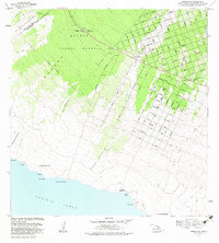
Other maps of this area

1924 · Kalae
USGS Topo · 1:62,500

1924 · Honuapo
USGS Topo · 1:62,500

1928 · Hoopuloa
USGS Topo · 1:62,500

1954 · Hawaii South
USGS Topo · 1:250,000

1959 · Hawaii South
USGS Topo · 1:250,000

1961 · Hawaii South
USGS Topo · 1:250,000

1962 · Hawaii South
USGS Topo · 1:250,000

1962 · Milolii
USGS Topo · 1:24,000

1962 · Puu Hou
USGS Topo · 1:24,000

1962 · Kahuku Ranch
USGS Topo · 1:24,000