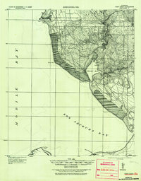
1921 Map of Point Clear
USGS Topo · Published 1936About this map
Mobile Bay and the eastern shores of Bon Secours Bay dominate this coastal landscape, which was surveyed by S. S. Winslow under the Corps of Engineers. The map documents a period before major modern development, where small settlements like Battles and Point Clear sit along the high ground of the western shoreline. Inland, the hydrology of the Fish River and its tributaries, including Turkey Branch and Collins Creek, shapes the settlement patterns near Marlow and Barnwell.
Find a feature on this map
24 named features on this map. Tap any name to fly to it.
Don’t see what you’re looking for? This feature index may not catch every label — zoom into the map to look around manually.
Map Details
Editions of this 1921 Point Clear Map
2 editions found
Other maps of this area

1920 · Robertsdale
USGS Topo · 1:62,500

1921 · Bon Secour
USGS Topo · 1:62,500

1921 · Point Clear
USGS Topo · 1:62,500

1921 · Fairhope
USGS Topo · 1:62,500

1921 · Dauphin Island
USGS Topo · 1:62,500

1921 · Delchamps
USGS Topo · 1:62,500

1922 · Mobile
USGS Topo · 1:62,500

1939 · Daphne
USGS Topo · 1:31,680

1940 · Silverhill
USGS Topo · 1:31,680

1940 · Hollingers Island
USGS Topo · 1:31,680