
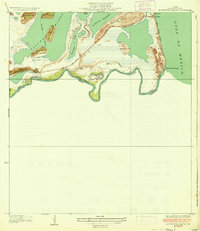
1929 Map of Point Isabel
USGS Topo · Published 1929About this map
Point Isabel serves as the focal point of this coastal survey, positioned where the Rio Grande Valley Railway and State Highway No 100 terminate at the edge of the Laguna Madre. The landscape is a complex network of mud flats, passes, and small elevated lomas, such as Loma de la Draga and Loma del Gato, which rise above the surrounding tidal terrain. This era of coastal navigation is marked by the Brazos Santiago Light and the Brazos Coast Guard Sta guarding the Brazos Santiago Pass. To the east, a Plank Road traverses the narrow sands of Padre Island, connecting the Brazos Coast Guard Sta to landmarks like the Hotel and Tarpon. The presence of an Aqueduct crossing the flats toward the mainland highlights the early engineering required to sustain this isolated port environment.
Find a feature on this map
30 named features on this map. Tap any name to fly to it.
Don’t see what you’re looking for? This feature index may not catch every label — zoom into the map to look around manually.
Map Details
Editions of this 1929 Point Isabel Map
This is the sole edition of this map. No revisions or reprints were ever made.
Other maps of this area

1929 · La Coma
USGS Topo · 1:24,000

1929 · Palmito Hill
USGS Topo · 1:24,000

1929 · Laguna Vista
USGS Topo · 1:24,000

1930 · Padre Island No. 1
USGS Topo · 1:24,000

1934 · Port Isabel
USGS Topo · 1:31,680

1934 · La Coma
USGS Topo · 1:31,680

1935 · Padre Island No 1
USGS Topo · 1:31,680

1936 · Palmito Hill
USGS Topo · 1:31,680

1936 · Laguna Vista
USGS Topo · 1:31,680
1936 · Mouth Of Rio Grande
USGS Topo · 1:31,680