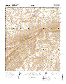
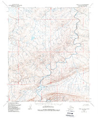
2014 Map of Point Lay A-3 SE
USGS Topo · Published 2014About this map
Amatusuk Hills dominate the topography of this remote Arctic interior, where complex drainage patterns define the landscape of the North Slope. Several watercourses, including Kuchiak Cr and Omalik Cr, carve through the elevations, illustrating the subtle but persistent erosion typical of the region's permafrost-underlain terrain. The mapping reveals a land shaped by seasonally active streams like Panikpiak Cr and Kahgratak Cr, which form a network of tributaries that eventually flow toward the Chukchi Sea. This 2014 survey by the U.S. Geological Survey and the Department of the Interior provides a precise record of these hydrological features within the Public Land Survey System grids, specifically tracking the boundaries of T4S R48W and T4S R47W. The absence of permanent infrastructure or settlements highlights the wilderness character of this borough, preserved for environmental study and traditional land use.
Find a feature on this map
9 named features on this map. Tap any name to fly to it.
Don’t see what you’re looking for? This feature index may not catch every label — zoom into the map to look around manually.
Map Details
Editions of this 2014 Point Lay A-3 SE Map
This is the sole edition of this map. No revisions or reprints were ever made.
Other maps of this area

1951 · De Long Mountains
USGS Topo · 1:250,000

1951 · Point Lay
USGS Topo · 1:250,000

1955 · De Long Mountains
USGS Topo · 1:250,000

1955 · Point Lay
USGS Topo · 1:250,000

1955 · De Long Mountains D-2
USGS Topo · 1:63,360
1955 · Point Lay A-3 & 4
USGS Topo · 1:63,360
1955 · Point Lay A-2
USGS Topo · 1:63,360
1955 · De Long Mountains D-3
USGS Topo · 1:63,360
1956 · Point Lay A-2
USGS Topo · 1:63,360

1965 · Point Lay
USGS Topo · 1:250,000