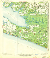
1939 Map of Point Washington
USGS Topo · Published 1939About this map
Point Washington and the surrounding shoreline of Jolly Bay anchor this 1930s coastal survey, depicting the intricate delta where the Choctawhatchee River meets the bay. The landscape is defined by a complex network of waterways, including Mitchell River, Sister River, and the Liveoak Cutoff, winding through landforms like Bunker Island and East River Island. Along the Gulf of Mexico, the Coast Highway provides the primary transit link between early coastal developments at Grayton Beach and Seagrove Beach.
Find a feature on this map
68 named features on this map. Tap any name to fly to it.
Don’t see what you’re looking for? This feature index may not catch every label — zoom into the map to look around manually.
Map Details
Editions of this 1939 Point Washington Map
3 editions found
Other maps of this area

1934 · Niceville
USGS Topo · 1:48,000

1935 · Villa Tasso
USGS Topo · 1:48,000

1935 · De Funiak Springs
USGS Topo · 1:48,000

1936 · Niceville
USGS Topo · 1:62,500

1936 · Point Washington
USGS Topo · 1:48,000

1938 · Villa Tasso
USGS Topo · 1:62,500

1938 · De Funiak Springs
USGS Topo · 1:62,500

1939 · Point Washington
USGS Topo · 1:62,500

1943 · Laguna Beach
USGS Topo · 1:31,680

1943 · Seminole Hills
USGS Topo · 1:24,000