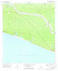
1970 Map of Point Washington
USGS Topo · Published 1977About this map
Point Washington sits at the northern edge of this coastal landscape, situated near Tucker Bayou and the winding Peach Creek. The area is defined by its transition from the dense wetlands of Devils Swamp to the white sands of the Gulf shore. The Intracoastal Waterway cuts a straight path through the northern terrain, contrasting with the irregular natural drainage of Roaring Creek and Tenmile Branch. Along the southern coastline, small developments like Seagrove Beach and Inlet Beach represent early steps in the regional shift toward coastal tourism. Numerous coastal dune lakes, including Eastern Lake, Deer Lake, and Camp Creek Lake, pockmark the shoreline, while a network of Jeep Trails provides the primary access to the interior. The presence of Pt Washington Base A suggests a history of surveying and coordinated infrastructure in this corner of Walton County.
Find a feature on this map
19 named features on this map. Tap any name to fly to it.
Don’t see what you’re looking for? This feature index may not catch every label — zoom into the map to look around manually.
Map Details
Editions of this 1970 Point Washington Map
Other maps of this area

1936 · Point Washington
USGS Topo · 1:48,000

1939 · Point Washington
USGS Topo · 1:62,500

1943 · Laguna Beach
USGS Topo · 1:31,680

1943 · Seminole Hills
USGS Topo · 1:24,000

1944 · Seminole Hills
USGS Topo · 1:31,680

1944 · Bruce
USGS Topo · 1:24,000

1945 · Bruce
USGS Topo · 1:31,680

1954 · Tallahassee
USGS Topo · 1:250,000

1957 · Pensacola
USGS Topo · 1:250,000

1959 · Tallahassee
USGS Topo · 1:250,000