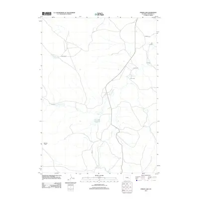
2012 Map of Poison Lake
USGS Topo · Published 2012About this map
Old Camp Marshall and the historic Emigrant Trl define the northern corridor of this Wyoming landscape, marking a legacy of westward passage in Converse County. The terrain is characterized by a network of drainage systems, including the serpentine path of La Bonte Cr and its W Fork La Bonte Cr, which flow toward the Saddleback Reservoir. This is ranching country, evidenced by the scattered locations of the Nunn Ranch, Johnson Ranch, Norton Ranch, and Willox Ranch, representing the enduring agricultural footprint of the region. Local landmarks like Poison Lake and Manning Ridge offer specific orientation points for researchers tracing land ownership or historical transit routes through the high plains. The map provides a detailed look at the rural infrastructure near the turn of the 21st century, from the winding Poison Lake Rd to the southern reaches of Braae Rd.
Find a feature on this map
15 named features on this map. Tap any name to fly to it.
Don’t see what you’re looking for? This feature index may not catch every label — zoom into the map to look around manually.
Map Details
Editions of this 2012 Poison Lake Map
This is the sole edition of this map. No revisions or reprints were ever made.
Other maps of this area

1943 · Esterbrook
USGS Topo · 1:62,500

1945 · Esterbrook
USGS Topo · 1:62,500

1949 · Irvine
USGS Topo · 1:24,000

1949 · Poison Lake
USGS Topo · 1:24,000

1949 · Dilts Ranch
USGS Topo · 1:24,000

1949 · Chalk Buttes
USGS Topo · 1:24,000

1950 · Poison Lake
USGS Topo · 1:24,000
1950 · Irvine
USGS Topo · 1:24,000
1950 · Dilts Ranch
USGS Topo · 1:24,000
1950 · Chalk Buttes
USGS Topo · 1:24,000