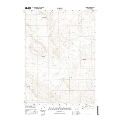
2015 Map of Poison Lake
USGS Topo · Published 2015About this map
The historical Emigrant Trl cuts across the northeastern corner of this Converse County landscape, marking a legacy of westward expansion through the high plains. Water management defines much of the human footprint here, visible through irrigation and stock control features like Darlington Reservoir Number 1, Trail Reservoir Number 1, and Saddleback Reservoir. These man-made catchments sit alongside natural features such as the eponymous Poison Lake and the prominent Manning Ridge. The drainage system is dominated by the forks of La Bonte Cr, including W-Fork-La-Bonte Cr, which carve through the terrain alongside Trail Cr and Mill Cr. Modern access is provided by rural routes like Esterbrook Rd and Braae Rd, connecting the scattered ranching interests that have historically utilized these drainages for livestock in the open range of eastern Wyoming.
Find a feature on this map
19 named features on this map. Tap any name to fly to it.
Don’t see what you’re looking for? This feature index may not catch every label — zoom into the map to look around manually.
Map Details
Editions of this 2015 Poison Lake Map
This is the sole edition of this map. No revisions or reprints were ever made.
Other maps of this area

1943 · Esterbrook
USGS Topo · 1:62,500

1945 · Esterbrook
USGS Topo · 1:62,500

1949 · Irvine
USGS Topo · 1:24,000

1949 · Poison Lake
USGS Topo · 1:24,000

1949 · Dilts Ranch
USGS Topo · 1:24,000

1949 · Chalk Buttes
USGS Topo · 1:24,000

1950 · Poison Lake
USGS Topo · 1:24,000
1950 · Irvine
USGS Topo · 1:24,000
1950 · Dilts Ranch
USGS Topo · 1:24,000
1950 · Chalk Buttes
USGS Topo · 1:24,000