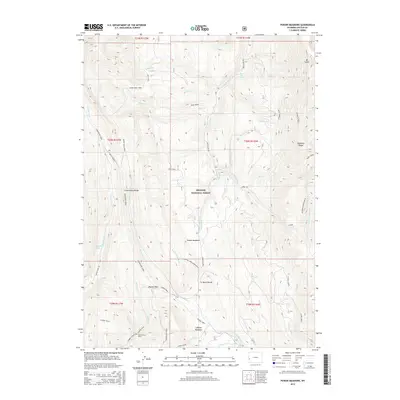
2015 Map of Poison Meadows
USGS Topo · Published 2015About this map
Estella Brown Grave stands as a solitary historical marker within the high elevations of the Bridger National Forest. This section of the Wyoming mountains is defined by the historical path of the Lander Trail, which cuts through the southern portion of the sheet near LaBarge Meadows. The map illustrates a critical hydrologic and geographic nexus at the Tri Basin Divide, where waters separate toward distinct drainage systems. The landscape is dominated by the massive north-south spine of Commissary Ridge and the Wyoming Range, with Wyoming Peak marking one of the highest points of relief. Numerous watercourses, including the Greys River and La Barge Cr, originate in these alpine meadows, creating a complex network of canyons and ridges that historically challenged western migration along the Hobble Creek Lander Trail.
Find a feature on this map
49 named features on this map. Tap any name to fly to it.
Don’t see what you’re looking for? This feature index may not catch every label — zoom into the map to look around manually.
Map Details
Editions of this 2015 Poison Meadows Map
This is the sole edition of this map. No revisions or reprints were ever made.
Other maps of this area

1921 · Afton
USGS Topo · 1:125,000

1936 · Cokeville
USGS Topo · 1:96,000

1942 · Cokeville
USGS Topo · 1:125,000

1955 · Preston
USGS Topo · 1:250,000

1958 · Preston
USGS Topo · 1:250,000

1962 · Preston
USGS Topo · 1:250,000

1967 · Graham Peak
USGS Topo · 1:24,000

1967 · Porcupine Creek
USGS Topo · 1:24,000

1967 · Mount Thompson
USGS Topo · 1:24,000
1980 · Mount Schidler
USGS Topo · 1:24,000