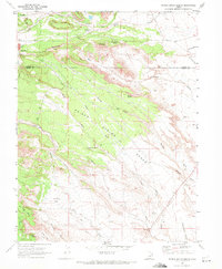
1969 Map of Poison Spring Bench
USGS Topo · Published 1972About this map
Hiawatha anchors the northwest corner of this 1969 topographic study, where industrial infrastructure including a Substa and a Tailings Pond reflects the area's mining history at the Carbon and Emery county line. The map captures a landscape defined by seasonal drainages and flat-topped mesas, most notably the central Poison Spring Bench. Water sources are vital markers in this arid terrain, with several named springs such as Clawson Spring, Goat Ranch Spring, and Cottonwood Spring providing life to the surrounding canyons. To the south, the topography transitions into open areas like Trimble Flat and Nosey Joe Flat, bordered by features such as The Gumhill and Oil Well Bench. The presence of a Pipeline and scattered resource extraction sites like a Borrow Pit and Gravel Pit indicate the mid-century development of local energy and construction industries.
Find a feature on this map
33 named features on this map. Tap any name to fly to it.
Don’t see what you’re looking for? This feature index may not catch every label — zoom into the map to look around manually.
Map Details
Editions of this 1969 Poison Spring Bench Map
3 editions found
Other maps of this area

1885 · Manti
USGS Topo · 1:250,000

1886 · Price River
USGS Topo · 1:250,000

1895 · Manti
USGS Topo · 1:250,000

1896 · Price River
USGS Topo · 1:250,000

1914 · Castle Gate
USGS Topo · 1:62,500

1916 · Castle Gate
USGS Topo · 1:62,500

1923 · Scofield
USGS Topo · 1:62,500

1923 · Hiawatha
USGS Topo · 1:62,500

1925 · Scofield
USGS Topo · 1:62,500

1925 · Hiawatha
USGS Topo · 1:62,500