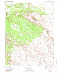
1969 Map of Poison Spring Bench
USGS Topo · Published 1983About this map
Hiawatha and its surrounding coal-country infrastructure dominate the northwestern corner of this Emery and Carbon County landscape during the late 1960s. The heavy industrial presence of the Utah Railway and a large Tailings Pond contrast sharply with the expansive, arid drainages of Poison Spring Bench. Water sources like Clawson Spring, Goat Ranch Spring, and Cottonwood Spring are carefully noted across this high-desert terrain, indicating their vital importance for livestock and local operations. The map reveals a transition from industrial activity to more primitive accessibility, marked by a Jeep Trail winding through Jackass Wash and past Oil Well Bench. The intricate network of washes, including Washboard Wash and Timothy Wash, underscores the complex erosion patterns that define the region's geography between Miller Creek and Nosey Joe Creek.
Find a feature on this map
30 named features on this map. Tap any name to fly to it.
Don’t see what you’re looking for? This feature index may not catch every label — zoom into the map to look around manually.
Map Details
Editions of this 1969 Poison Spring Bench Map
3 editions found
Other maps of this area

1885 · Manti
USGS Topo · 1:250,000

1886 · Price River
USGS Topo · 1:250,000

1895 · Manti
USGS Topo · 1:250,000

1896 · Price River
USGS Topo · 1:250,000

1914 · Castle Gate
USGS Topo · 1:62,500

1916 · Castle Gate
USGS Topo · 1:62,500

1923 · Scofield
USGS Topo · 1:62,500

1923 · Hiawatha
USGS Topo · 1:62,500

1925 · Scofield
USGS Topo · 1:62,500

1925 · Hiawatha
USGS Topo · 1:62,500