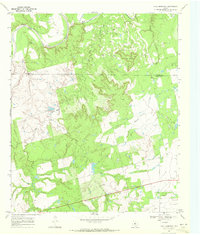
1969 Map of Poke Mountain
USGS Topo · Published 1972About this map
The Double Mountain Fork Brazos River winds through a landscape defined by the convergence of steep breaks and the Texas cattle and oil economy of the late 1960s. Straddling the Stonewall and Fisher county line, the terrain transitions from the deep incisions of Poke Canyon and Poke Mountain to the rolling ranchlands of the southern half. Cultural landmarks such as Sacred Heart Ch and Mount Zion Cem anchor the rural community, while the Crescent Ranch illustrates the expansive land use of the period. The map documents an active extractive landscape, scattered with numerous Oil Wells and a Pipeline, alongside older geographical markers like Gap and the Bullock Creek drainage. This survey provides a precise look at the rural infrastructure of West Texas before modern consolidation, preserving the locations of family-named landmarks and local sites.
Find a feature on this map
18 named features on this map. Tap any name to fly to it.
Don’t see what you’re looking for? This feature index may not catch every label — zoom into the map to look around manually.
Map Details
Editions of this 1969 Poke Mountain Map
2 editions found
Other maps of this area

1893 · Roby
USGS Topo · 1:125,000

1926 · Roby 2-b
USGS Topo · 1:48,000

1931 · Rotan
USGS Topo · 1:62,500

1931 · Aspermont
USGS Topo · 1:62,500

1954 · Lubbock
USGS Topo · 1:250,000

1954 · Big Spring
USGS Topo · 1:250,000

1958 · Big Spring
USGS Topo · 1:250,000
1965 · Hamlin NW
USGS Topo · 1:24,000

1965 · McCaulley
USGS Topo · 1:24,000

1968 · Double Mountains
USGS Topo · 1:24,000