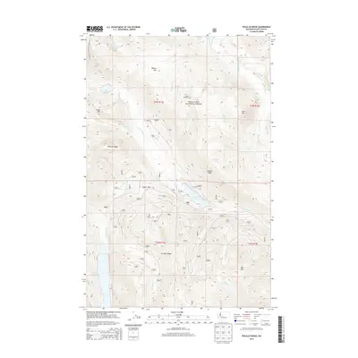
2014 Map of Polallie Ridge
USGS Topo · Published 2014About this map
Wenatchee National Forest encompasses this high-elevation landscape, where the Pacific Crest National Scenic Trail winds through the western ridges near Island Mtn and Pete Lake. The area is defined by its drainage systems and significant mountain passes, including Waptus Pass and Copper Pass, which historically served as vital corridors through the Cascade Range. Water features are central to the geography here, with Waptus Lake in the north and Cooper Lake in the south connected by a network of creeks like Tumble Cr and Quick Cr. The prominent Polallie Ridge stands as a central divide, once topped by the Polallie Ridge Lookout, overlooking the Waptus River and Cooper River valleys. This survey illustrates the intricate alpine topography and the established trail systems used by travelers and forest rangers in the early 21st century.
Find a feature on this map
31 named features on this map. Tap any name to fly to it.
Don’t see what you’re looking for? This feature index may not catch every label — zoom into the map to look around manually.
Map Details
Editions of this 2014 Polallie Ridge Map
This is the sole edition of this map. No revisions or reprints were ever made.
Other maps of this area

1901 · Snoqualmie Pass
USGS Topo · 1:125,000

1902 · Skykomish
USGS Topo · 1:125,000

1903 · Snoqualmie
USGS Topo · 1:125,000

1905 · Skykomish
USGS Topo · 1:125,000

1957 · Wenatchee
USGS Topo · 1:250,000

1961 · Snoqualmie Pass
USGS Topo · 1:62,500

1961 · Kachess Lake
USGS Topo · 1:62,500

1965 · Mount Daniel
USGS Topo · 1:24,000
1965 · Big Snow Mtn
USGS Topo · 1:24,000
1965 · The Cradle
USGS Topo · 1:24,000