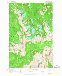
1965 Map of Big Snow Mtn
USGS Topo · Published 1967About this map
Snoqualmie National Forest and Wenatchee National Forest converge at the ridge of the Cascade Crest in this mid-1960s topographic study. The landscape is dominated by massive peaks and a dense network of high-altitude glacial lakes. Notable summits include Big Snow Mtn, Summit Chief Mtn, and the sharp profile of Chimney Rock near the King-Kittitas County line. The alpine character of the terrain is evident in the cluster of water bodies such as Angeline Lake, Big Heart Lake, and the series of lakes in the Necklace Valley, including Jade Lake and Emerald Lake. Hikers and climbers of the era relied on the sparse Trail and Pack Trail systems to navigate the steep elevations between Copper Lake and Fools Gold Lake.
Find a feature on this map
64 named features on this map. Tap any name to fly to it.
Don’t see what you’re looking for? This feature index may not catch every label — zoom into the map to look around manually.
Map Details
Editions of this 1965 Big Snow Mtn Map
4 editions found
Other maps of this area

1901 · Snoqualmie Pass
USGS Topo · 1:125,000

1902 · Skykomish
USGS Topo · 1:125,000

1903 · Snoqualmie
USGS Topo · 1:125,000

1905 · Skykomish
USGS Topo · 1:125,000

1957 · Wenatchee
USGS Topo · 1:250,000

1961 · Snoqualmie Pass
USGS Topo · 1:62,500

1961 · Kachess Lake
USGS Topo · 1:62,500

1965 · Grotto
USGS Topo · 1:24,000

1965 · Mount Daniel
USGS Topo · 1:24,000

1965 · Skykomish
USGS Topo · 1:24,000