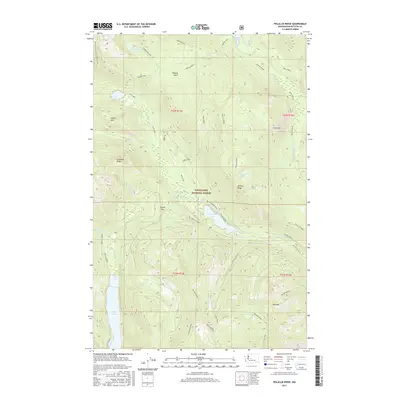
2017 Map of Polallie Ridge
USGS Topo · Published 2017About this map
Wenatchee National Forest encompasses this high-elevation landscape, where glacial waters and narrow drainage corridors define the terrain of the Central Cascades. Significant water bodies including Waptus Lake, Cooper Lake, and the northern reach of Kachess Lake serve as major focal points for the region's geography. The Pacific Crest National Scenic Trail traverses the western portion of the map, intersecting with local routes like the Pete Lake trail and the Road Tie near Waptus Pass. This network of paths and forest development roads, such as Nat For Dev Rd 4600 near the Owhi Campground, illustrates the modern infrastructure supporting recreation and forest management. Distinctive peaks and ridges, including Island Mtn, Red Mountain, and the eponymous Polallie Ridge, overlook a complex system of creeks such as Tired Creek and the Lemah Cr drainage.
Find a feature on this map
51 named features on this map. Tap any name to fly to it.
Don’t see what you’re looking for? This feature index may not catch every label — zoom into the map to look around manually.
Map Details
Editions of this 2017 Polallie Ridge Map
This is the sole edition of this map. No revisions or reprints were ever made.
Other maps of this area

1901 · Snoqualmie Pass
USGS Topo · 1:125,000

1902 · Skykomish
USGS Topo · 1:125,000

1903 · Snoqualmie
USGS Topo · 1:125,000

1905 · Skykomish
USGS Topo · 1:125,000

1957 · Wenatchee
USGS Topo · 1:250,000

1961 · Snoqualmie Pass
USGS Topo · 1:62,500

1961 · Kachess Lake
USGS Topo · 1:62,500

1965 · Mount Daniel
USGS Topo · 1:24,000
1965 · Big Snow Mtn
USGS Topo · 1:24,000
1965 · The Cradle
USGS Topo · 1:24,000