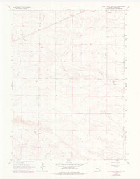
1963 Map of Pole Creek Ranch SE
USGS Topo · Published 1978About this map
Berry Ranch and Johnson Ranch anchor the northern landscape of this Laramie County survey, representing the enduring pastoral operations of the Wyoming high plains in the early 1960s. The terrain is defined by a network of drainage channels, most notably Antelope Draw and Chivington Draw, which carve through the high ground to the north. In the southern portion of the quadrangle, Lodgepole Creek meanders eastward, creating a distinct hydrological corridor across the township boundaries. A small Gravel Pit near the eastern edge indicates localized resource extraction amidst the broad grazing lands. Updated with photorevisions in the late 1970s, the map provides a look at the precise fencing and land management patterns of the era, reflecting the systematic organization of the ranching industry.
Find a feature on this map
6 named features on this map. Tap any name to fly to it.
Don’t see what you’re looking for? This feature index may not catch every label — zoom into the map to look around manually.
Map Details
Editions of this 1963 Pole Creek Ranch SE Map
2 editions found
Other maps of this area

1911 · Cheyenne
USGS Topo · 1:125,000

1914 · Cheyenne
USGS Topo · 1:125,000

1954 · Cheyenne
USGS Topo · 1:250,000

1958 · Cheyenne
USGS Topo · 1:250,000

1963 · Little Indian Draw
USGS Topo · 1:24,000

1963 · Pole Creek Ranch SE
USGS Topo · 1:24,000

1963 · Midway
USGS Topo · 1:24,000

1963 · Durham
USGS Topo · 1:24,000

1963 · Midway SW
USGS Topo · 1:24,000
1963 · Pole Creek Ranch
USGS Topo · 1:24,000