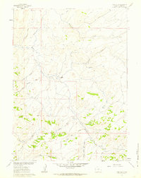
1961 Map of Pole Gulch
USGS Topo · Published 1963About this map
The McKee Homestead stands as a lonely marker of pioneer settlement in this high-altitude landscape of Carbon County, Wyoming, as it appeared in the early 1960s. The terrain is defined by a dense network of drainages and intermittent streams, including the central Muddy Creek and its many tributaries like Horse Springs Draw and Deep Gulch. This area preserves the historical alignment of the Emigrant Bridger Pass Trail, a critical route for early transcontinental travel that winds through the Northwest portion of the quadrangle. The physical geography is dominated by high ridges and peaks, most notably the high point at Sierra VABM 8269 in the southeast corner. Cattle-country landmarks such as Littlefield and Canary Grove Draw indicate the continued agricultural and grazing use of the land following the era of migration.
Find a feature on this map
18 named features on this map. Tap any name to fly to it.
Don’t see what you’re looking for? This feature index may not catch every label — zoom into the map to look around manually.
Map Details
Editions of this 1961 Pole Gulch Map
2 editions found
Other maps of this area

1932 · Savery
USGS Topo · 1:96,000

1940 · Savery
USGS Topo · 1:125,000

1954 · Rawlins
USGS Topo · 1:250,000

1956 · Bridger Pass
USGS Topo · 1:62,500

1957 · Doty Mountain
USGS Topo · 1:62,500

1958 · Rawlins
USGS Topo · 1:250,000

1961 · Pine Grove Ranch
USGS Topo · 1:24,000

1961 · Ketchum Buttes
USGS Topo · 1:24,000

1961 · Pole Gulch
USGS Topo · 1:24,000
1961 · Mc Carty Ranch
USGS Topo · 1:24,000