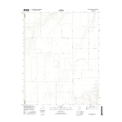
2016 Map of Pollard Creek NE
USGS Topo · Published 2016About this map
S Palo Duro Cr carves a distinctive path through the northwestern corner of this Moore County landscape, defining the local drainage patterns across the high plains. The topography is otherwise marked by a highly regular grid of rural infrastructure, where Co Rd 4 and Co Rd 7 intersect with regional connectors like Ranch Rd 1598. This 2016 survey illustrates the persistent ranching and agricultural framework along the boundary of Moore Co and Hutchinson Co. The placement of numerous small ponds and depressions alongside routes such as Ranch Rd 1923 highlights the importance of water management in this arid Panhandle environment, while the proximity of FM 1598 shows the evolution of the local transportation network into its modern form.
Find a feature on this map
16 named features on this map. Tap any name to fly to it.
Don’t see what you’re looking for? This feature index may not catch every label — zoom into the map to look around manually.
Map Details
Editions of this 2016 Pollard Creek NE Map
This is the sole edition of this map. No revisions or reprints were ever made.
Other maps of this area

1953 · Stinnett
USGS Topo · 1:24,000

1953 · Pringle
USGS Topo · 1:24,000

1954 · Perryton
USGS Topo · 1:250,000

1954 · Amarillo
USGS Topo · 1:250,000

1958 · Perryton
USGS Topo · 1:250,000

1958 · Amarillo
USGS Topo · 1:250,000
1972 · Pollard Creek
USGS Topo · 1:24,000

1972 · Capps Switch
USGS Topo · 1:24,000
1972 · Pollard Creek NW
USGS Topo · 1:24,000

1974 · Morse
USGS Topo · 1:24,000