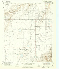
1974 Map of Pollard Creek NE
USGS Topo · Published 1977About this map
Palo Duro Creek and its tributary, South Palo Duro Creek, carve through the High Plains landscape of the Texas Panhandle in this mid-1970s survey. The map documents an industrial landscape defined by the extensive Gas And Oil Field, where a dense network of pipelines, wells, and a central Pumping Sta reveal the intensity of energy extraction during this era. The county line between Moore Co and Hutchinson Co bisects the western portion of the sheet, where Stewart Station serves as a small localized landmark amidst the infrastructure. Beyond the energy sector, the map records a Gravel Pit along the creek bluffs, illustrating how the natural topography was utilized for local materials while the underlying mineral resources were tapped by an grid-like system of gas wells and access roads.
Find a feature on this map
7 named features on this map. Tap any name to fly to it.
Don’t see what you’re looking for? This feature index may not catch every label — zoom into the map to look around manually.
Map Details
Editions of this 1974 Pollard Creek NE Map
This is the sole edition of this map. No revisions or reprints were ever made.
Other maps of this area

1953 · Stinnett
USGS Topo · 1:24,000

1953 · Pringle
USGS Topo · 1:24,000

1954 · Perryton
USGS Topo · 1:250,000

1954 · Amarillo
USGS Topo · 1:250,000

1958 · Perryton
USGS Topo · 1:250,000

1958 · Amarillo
USGS Topo · 1:250,000
1972 · Pollard Creek
USGS Topo · 1:24,000

1972 · Capps Switch
USGS Topo · 1:24,000
1972 · Pollard Creek NW
USGS Topo · 1:24,000

1974 · Morse
USGS Topo · 1:24,000