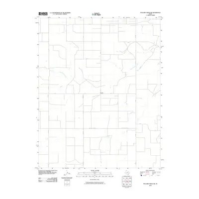
2010 Map of Pollard Creek NW
USGS Topo · Published 2010About this map
South Palo Duro Creek carves a winding path across this Moore County landscape, providing a natural break in the strictly ordered agricultural grid. This 2010 survey illustrates the intersection of rural infrastructure and local history, anchored by the Palo Duro Cemetery located near the center of the quadrangle. The map details a network of farm-to-market roads and named thoroughfares such as Morton Elevator Rd, Keith Rd, and Hooks Rd, which facilitate the region's agricultural economy. State-maintained routes FM 1060 and FM 1598 converge in the eastern portion of the sheet, reflecting the modern transportation framework used to navigate these plains. The systematic naming of east-west roads like E Rd E and E Rd I further underscores the precision of the local land management system.
Find a feature on this map
14 named features on this map. Tap any name to fly to it.
Don’t see what you’re looking for? This feature index may not catch every label — zoom into the map to look around manually.
Map Details
Editions of this 2010 Pollard Creek NW Map
This is the sole edition of this map. No revisions or reprints were ever made.
Other maps of this area

1954 · Perryton
USGS Topo · 1:250,000

1954 · Amarillo
USGS Topo · 1:250,000

1958 · Perryton
USGS Topo · 1:250,000

1958 · Amarillo
USGS Topo · 1:250,000
1972 · Little Blue Creek
USGS Topo · 1:24,000

1972 · Dumas NE
USGS Topo · 1:24,000
1972 · Pollard Creek
USGS Topo · 1:24,000

1972 · Capps Switch
USGS Topo · 1:24,000

1972 · Sunray
USGS Topo · 1:24,000
1972 · Pollard Creek NW
USGS Topo · 1:24,000