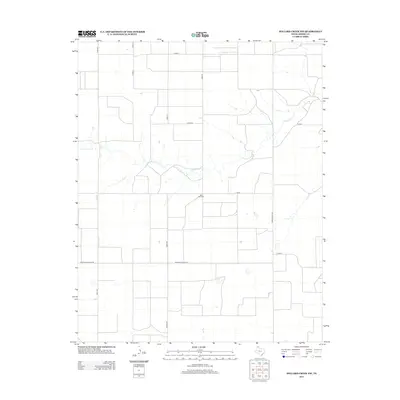
2012 Map of Pollard Creek NW
USGS Topo · Published 2012About this map
The vast agricultural plains of the Texas Panhandle define this landscape, where the primary topographic relief is carved by the winding course of S Palo Duro Cr. This section of Moore County is organized by a rigid grid of rural arteries, including Keith Rd and Hooks Rd, which connect isolated farmsteads and agricultural operations. A significant point of local history is found at the Palo Duro Cem, a small burial ground situated just north of E Road I. The map captures an era of modern industrial farming, evident in the naming of thoroughfares such as Morton Elevator Rd, reflecting the regional reliance on grain storage and transport. Sparse vegetation and seasonal water catchments dot the level terrain between the primary state and county routes like FM-1598 and Ranch Road 1060.
Find a feature on this map
15 named features on this map. Tap any name to fly to it.
Don’t see what you’re looking for? This feature index may not catch every label — zoom into the map to look around manually.
Map Details
Editions of this 2012 Pollard Creek NW Map
This is the sole edition of this map. No revisions or reprints were ever made.
Other maps of this area

1954 · Perryton
USGS Topo · 1:250,000

1954 · Amarillo
USGS Topo · 1:250,000

1958 · Perryton
USGS Topo · 1:250,000

1958 · Amarillo
USGS Topo · 1:250,000
1972 · Little Blue Creek
USGS Topo · 1:24,000

1972 · Dumas NE
USGS Topo · 1:24,000
1972 · Pollard Creek
USGS Topo · 1:24,000

1972 · Capps Switch
USGS Topo · 1:24,000

1972 · Sunray
USGS Topo · 1:24,000
1972 · Pollard Creek NW
USGS Topo · 1:24,000