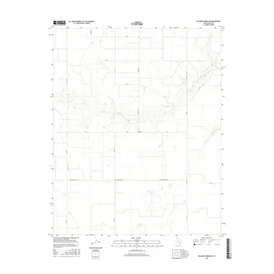
2016 Map of Pollard Creek NW
USGS Topo · Published 2016About this map
Palo Duro Cem sits atop a rise overlooking the winding valley of S Palo Duro Cr, which cuts a deep meandering path across this Panhandle landscape. The terrain is defined by a series of precise agricultural grids and section lines, with roads like Terrell Rd and Keith Rd marking the boundaries of the high plains. Industrial activity in this Moore County area is highlighted by Morton Elevator Rd, indicating the importance of local grain transport and storage. While much of the sheet is occupied by open rangeland and fields, the concentration of farm-to-market routes including FM 1060 and FM 1598 shows the established network connecting these rural spaces to larger regional hubs. The intermittent nature of the waterways and the presence of numerous small cattle tanks or depressions reflect the arid environment typical of the northern Texas plains.
Find a feature on this map
16 named features on this map. Tap any name to fly to it.
Don’t see what you’re looking for? This feature index may not catch every label — zoom into the map to look around manually.
Map Details
Editions of this 2016 Pollard Creek NW Map
This is the sole edition of this map. No revisions or reprints were ever made.
Other maps of this area

1954 · Perryton
USGS Topo · 1:250,000

1954 · Amarillo
USGS Topo · 1:250,000

1958 · Perryton
USGS Topo · 1:250,000

1958 · Amarillo
USGS Topo · 1:250,000
1972 · Little Blue Creek
USGS Topo · 1:24,000

1972 · Dumas NE
USGS Topo · 1:24,000
1972 · Pollard Creek
USGS Topo · 1:24,000

1972 · Capps Switch
USGS Topo · 1:24,000

1972 · Sunray
USGS Topo · 1:24,000
1972 · Pollard Creek NW
USGS Topo · 1:24,000