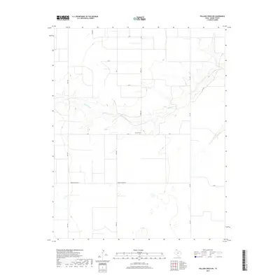
2019 Map of Pollard Creek NW
USGS Topo · Published 2019About this map
S Palo Duro Cr carves a distinct path through this section of the Texas Panhandle, creating a break in the otherwise orderly grid of agricultural roads. The landscape is defined by its rural layout, where long-established routes like Keith Rd and Hooks Rd navigate the open terrain of Moore County. This area represents the intersection of ranching traditions and modern infrastructure, characterized by the presence of the isolated Palo Duro Cem positioned along E Rd I. The drainage patterns of the creek and its surrounding breaks offer a sharp contrast to the flat, section-lined uplands. Infrastructure supporting local industry is evident through specialized routes such as Morton Elevator Rd, while Fm 1060 and Fm 1598 facilitate connectivity across this sparsely populated portion of the High Plains.
Find a feature on this map
16 named features on this map. Tap any name to fly to it.
Don’t see what you’re looking for? This feature index may not catch every label — zoom into the map to look around manually.
Map Details
Editions of this 2019 Pollard Creek NW Map
This is the sole edition of this map. No revisions or reprints were ever made.
Other maps of this area

1954 · Perryton
USGS Topo · 1:250,000

1954 · Amarillo
USGS Topo · 1:250,000

1958 · Perryton
USGS Topo · 1:250,000

1958 · Amarillo
USGS Topo · 1:250,000
1972 · Little Blue Creek
USGS Topo · 1:24,000

1972 · Dumas NE
USGS Topo · 1:24,000
1972 · Pollard Creek
USGS Topo · 1:24,000

1972 · Capps Switch
USGS Topo · 1:24,000

1972 · Sunray
USGS Topo · 1:24,000
1972 · Pollard Creek NW
USGS Topo · 1:24,000