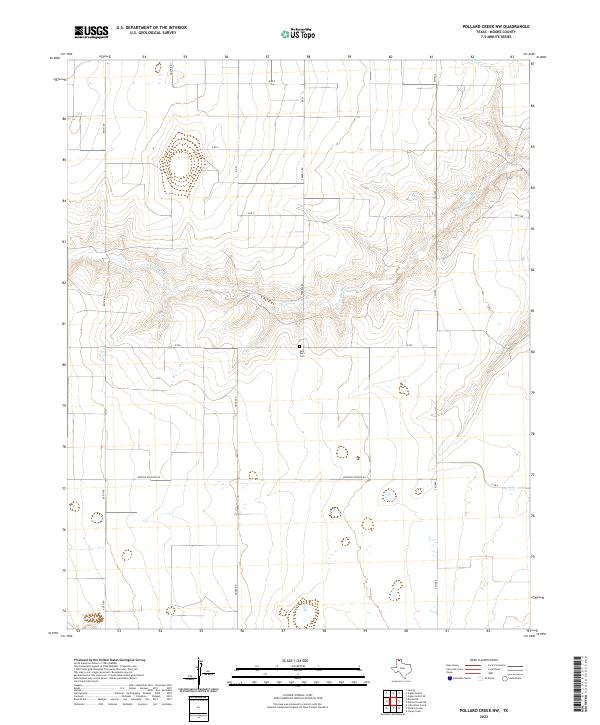
2022 Map of Pollard Creek NW
USGS Topo · Published 2022About this map
S Palo Duro Cr carves a winding path across this Moore County landscape, defining the topography of an area otherwise dominated by the geometric precision of the High Plains road grid. The presence of the Palo Duro Cem near the center of the sheet suggests the long-standing roots of the local ranching or farming community, serving as a focal point for genealogical interest in this part of the Texas Panhandle. Transport and local industry are primarily oriented around rural thoroughfares such as Morton Elevator Rd and Terrell Rd, which facilitate the movement of goods across these expansive agricultural sections. The map reveals the relationship between the natural drainage of the creek and the human-imposed boundaries of county roads like Keith Rd and Hooks Rd, showing how modern land use persists alongside the primary watercourse of the region.
Find a feature on this map
16 named features on this map. Tap any name to fly to it.
Don’t see what you’re looking for? This feature index may not catch every label — zoom into the map to look around manually.
Map Details
Editions of this 2022 Pollard Creek NW Map
This is the sole edition of this map. No revisions or reprints were ever made.
Other maps of this area

1954 · Perryton
USGS Topo · 1:250,000

1954 · Amarillo
USGS Topo · 1:250,000

1958 · Perryton
USGS Topo · 1:250,000

1958 · Amarillo
USGS Topo · 1:250,000
1972 · Little Blue Creek
USGS Topo · 1:24,000

1972 · Dumas NE
USGS Topo · 1:24,000
1972 · Pollard Creek
USGS Topo · 1:24,000

1972 · Capps Switch
USGS Topo · 1:24,000

1972 · Sunray
USGS Topo · 1:24,000
1972 · Pollard Creek NW
USGS Topo · 1:24,000