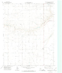
1972 Map of Pollard Creek NW
USGS Topo · Published 1974About this map
The South Palo Duro Creek carves a deep meandering path across the High Plains of Moore County in this early 1970s survey. The landscape is defined by the massive infrastructure of the Oil And Gas Field, where a dense network of pipelines and hundreds of Gas Wells and Oil Wells populate the tablelands. This energy production sits alongside agricultural markers like the Morton Elevator, illustrating the dual economic drivers of the Texas Panhandle. For family historians, the Palo Duro Cem remains a significant landmark near the center of the sheet, while industrial features such as a Pumping Sta and a Gravel Pit highlight the literal extraction of resources from the plains during this era of peak domestic production.
Find a feature on this map
9 named features on this map. Tap any name to fly to it.
Don’t see what you’re looking for? This feature index may not catch every label — zoom into the map to look around manually.
Map Details
Editions of this 1972 Pollard Creek NW Map
This is the sole edition of this map. No revisions or reprints were ever made.
Other maps of this area

1954 · Perryton
USGS Topo · 1:250,000

1954 · Amarillo
USGS Topo · 1:250,000

1958 · Perryton
USGS Topo · 1:250,000

1958 · Amarillo
USGS Topo · 1:250,000
1972 · Little Blue Creek
USGS Topo · 1:24,000

1972 · Dumas NE
USGS Topo · 1:24,000
1972 · Pollard Creek
USGS Topo · 1:24,000

1972 · Capps Switch
USGS Topo · 1:24,000

1972 · Sunray
USGS Topo · 1:24,000
1974 · Camp Creek
USGS Topo · 1:24,000