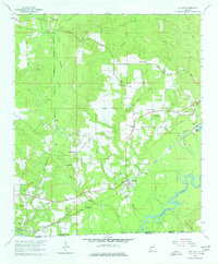
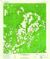
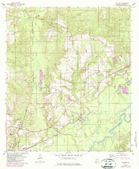
1960 Map of Pollard
USGS Topo · Published 1974About this map
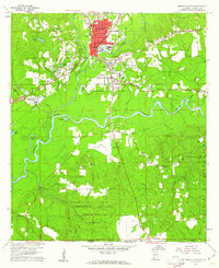
The Conecuh River flows along the southern edge of this 1960 landscape, where the confluence of numerous creeks shaped the early development of Escambia County. The dominant infrastructure of the era is the Louisville and Nashville railroad, which links the settlements of Pollard and Flomaton to smaller stops like Osaka and Wahl. A notable concentration of oil wells in the central sections suggests the industrial shift toward petroleum production during this period, alongside traditional operations like the Sandpit and Claypit. Local life centers around a network of country churches such as Beulah Ch and Catawba Springs Ch, with McCall Sch serving the rural population. The map also records family-linked landmarks like the Henderson Cem and Hollywood Cem, providing specific evidence for genealogical research in this border region near the Alabama-Florida state line.
Find a feature on this map
45 named features on this map. Tap any name to fly to it.
Don’t see what you’re looking for? This feature index may not catch every label — zoom into the map to look around manually.
Map Details
Editions of this 1960 Pollard Map
3 editions found
Other maps of this area

1941 · Century
USGS Topo · 1:62,500

1943 · Century
USGS Topo · 1:62,500

1943 · Jay
USGS Topo · 1:62,500

1953 · Andalusia
USGS Topo · 1:250,000

1957 · Andalusia
USGS Topo · 1:250,000

1957 · Pensacola
USGS Topo · 1:250,000

1959 · Pensacola
USGS Topo · 1:250,000
1959 · Brewton South
USGS Topo · 1:24,000

1960 · Pensacola
USGS Topo · 1:250,000
1960 · Brewton South
USGS Topo · 1:24,000