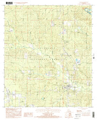
1999 Map of Pollock
USGS Topo · Published 2001About this map
The Kisatchie National Forest dominates the interior of this central Louisiana landscape, where the Louisiana Meridian serves as a primary north-south surveying line through the wooded terrain. Settled areas like Pollock and Bentley are situated along the southern and western margins, connected by a network of roads that weave through the drainage basins of Big Creek and Sugar Branch. This late-century survey reveals the heavy emphasis on silviculture in the region, most notably seen at the Stuart Pine Seed Orchard near the south-central border.
Find a feature on this map
31 named features on this map. Tap any name to fly to it.
Don’t see what you’re looking for? This feature index may not catch every label — zoom into the map to look around manually.
Map Details
Editions of this 1999 Pollock Map
This is the sole edition of this map. No revisions or reprints were ever made.
Other maps of this area

1932 · Colfax NE
USGS Topo · 1:31,680

1932 · Boyce NE
USGS Topo · 1:31,680

1932 · Colfax SE
USGS Topo · 1:31,680

1936 · Colfax
USGS Topo · 1:62,500

1936 · Pollock
USGS Topo · 1:62,500

1941 · Alexandria
USGS Topo · 1:62,500

1941 · Pollock
USGS Topo · 1:62,500

1941 · Boyce
USGS Topo · 1:62,500

1953 · Alexandria
USGS Topo · 1:250,000

1955 · Alexandria
USGS Topo · 1:250,000