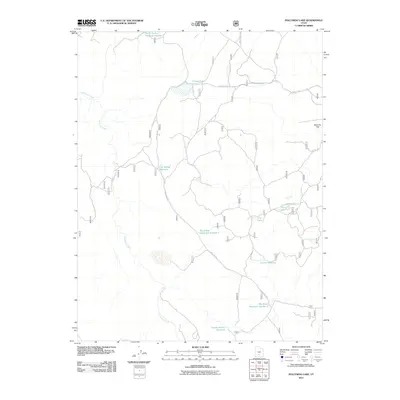
2011 Map of Pollywog Lake
USGS Topo · Published 2011About this map
Pollywog Lake and a series of managed water catchments define this high-elevation landscape in Garfield County. The network of reservoirs, including Death Hollow Reservoir Number 1 and two sites at Big Swale Reservoir Number 1, indicates a sophisticated system for water management in an area otherwise characterized by intermittent drainages. Water from Antimony Creek and various named sources like Lost Spring and Jackass Spring supports the local ecosystem, while a complex of forest roads provides access to isolated terrain like Butterfly Flat. This 2011 survey reflects the modern infrastructure of the Dixie National Forest, where the historical reliance on springs has been augmented by modern reservoir engineering to sustain the region's ranching and natural resources.
Find a feature on this map
18 named features on this map. Tap any name to fly to it.
Don’t see what you’re looking for? This feature index may not catch every label — zoom into the map to look around manually.
Map Details
Editions of this 2011 Pollywog Lake Map
This is the sole edition of this map. No revisions or reprints were ever made.
Other maps of this area

1885 · Fish Lake
USGS Topo · 1:250,000

1886 · Escalante
USGS Topo · 1:250,000

1896 · Fish Lake
USGS Topo · 1:250,000

1956 · Escalante
USGS Topo · 1:250,000

1956 · Salina
USGS Topo · 1:250,000

1960 · Escalante
USGS Topo · 1:250,000

1960 · Salina
USGS Topo · 1:250,000

1962 · Salina
USGS Topo · 1:250,000

1964 · Barker Reservoir
USGS Topo · 1:24,000
1964 · Grass Lakes
USGS Topo · 1:24,000