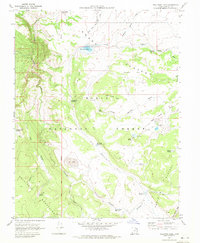
1970 Map of Pollywog Lake
USGS Topo · Published 1972About this map
Dixie National Forest dominates this high-altitude landscape in the early 1970s, where the transition between the Awapa Plateau and the Aquarius Plateau is marked by a complex system of water management. Numerous reservoirs, including Wildcat Reservoir, Pollywog Lake, and the numbered basins at Death Hollow and Big Swale, illustrate the critical importance of water storage in this arid timberland. The presence of the Salt Lake Meridian bisecting the survey area highlights the systematic grid of western land division, while labels like Antimony Creek and Antimony Knoll reflect the area's geological and mineral history. This survey captures a network of jeep trails and seasonal springs, such as Jackass Spring and Indian Spring, which supported livestock and forest management before modern infrastructure reached these remote elevations.
Find a feature on this map
43 named features on this map. Tap any name to fly to it.
Don’t see what you’re looking for? This feature index may not catch every label — zoom into the map to look around manually.
Map Details
Editions of this 1970 Pollywog Lake Map
This is the sole edition of this map. No revisions or reprints were ever made.
Other maps of this area

1885 · Fish Lake
USGS Topo · 1:250,000

1886 · Escalante
USGS Topo · 1:250,000

1896 · Fish Lake
USGS Topo · 1:250,000

1956 · Escalante
USGS Topo · 1:250,000

1956 · Salina
USGS Topo · 1:250,000

1960 · Escalante
USGS Topo · 1:250,000

1960 · Salina
USGS Topo · 1:250,000

1962 · Salina
USGS Topo · 1:250,000

1964 · Barker Reservoir
USGS Topo · 1:24,000
1964 · Grass Lakes
USGS Topo · 1:24,000