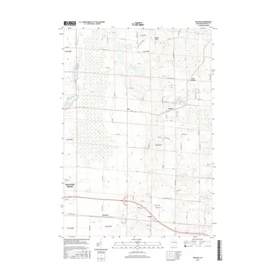
2015 Map of Polonia
USGS Topo · Published 2015About this map
Polonia and Custer anchor this section of Portage County, characterized by a transition from the agricultural uplands in the east to the riverine wetlands of the Plover River in the west. The landscape is defined by the glacial legacy of central Wisconsin, evident in the numerous water bodies such as Bakers Lake, Jordan Pond, and Oesterle Lake. In the northwest, the river's path creates the extensive Jordan Swamp, while the northeast corner is touched by the Tomorrow River. This 2015 survey shows a dense network of country roads connecting older hamlets like Ellis and Stockton with outlying areas like North Star and Little Waupon. The eastern edge of Stevens Point is visible along the western margin, illustrating the proximity of these rural communities to the regional urban center.
Find a feature on this map
85 named features on this map. Tap any name to fly to it.
Don’t see what you’re looking for? This feature index may not catch every label — zoom into the map to look around manually.
Map Details
Editions of this 2015 Polonia Map
This is the sole edition of this map. No revisions or reprints were ever made.
Other maps of this area

1955 · Rosholt
USGS Topo · 1:48,000

1955 · Green Bay
USGS Topo · 1:250,000

1956 · Stevens Point
USGS Topo · 1:48,000

1957 · Amherst
USGS Topo · 1:48,000

1957 · Whiting
USGS Topo · 1:48,000

1969 · Rosholt
USGS Topo · 1:24,000

1969 · New Hope
USGS Topo · 1:24,000

1969 · Arnott
USGS Topo · 1:24,000

1969 · Rosholt NW
USGS Topo · 1:24,000
1969 · Polonia
USGS Topo · 1:24,000