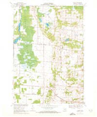
1969 Map of Polonia
USGS Topo · Published 1972About this map
Polonia and its surrounding Portage County countryside are defined by a mix of agricultural clearings and significant wetlands in the late 1960s. The landscape transitions from the expansive Jordan Swamp and the winding Plover River in the west to more elevated, rolling terrain near Oesterle Lake and Bakers Lake in the east. Small Catholic rural centers are prominent, notably the cluster around Sacred Heart Sch and the Cem at Polonia, as well as St Martin Ch and Edison Sch near the crossroads of Ellis.
Find a feature on this map
31 named features on this map. Tap any name to fly to it.
Don’t see what you’re looking for? This feature index may not catch every label — zoom into the map to look around manually.
Map Details
Editions of this 1969 Polonia Map
2 editions found
Other maps of this area

1955 · Rosholt
USGS Topo · 1:48,000

1955 · Green Bay
USGS Topo · 1:250,000

1956 · Stevens Point
USGS Topo · 1:48,000

1957 · Amherst
USGS Topo · 1:48,000

1957 · Whiting
USGS Topo · 1:48,000

1969 · Rosholt
USGS Topo · 1:24,000

1969 · New Hope
USGS Topo · 1:24,000

1969 · Arnott
USGS Topo · 1:24,000

1969 · Rosholt NW
USGS Topo · 1:24,000
1969 · Amherst
USGS Topo · 1:24,000