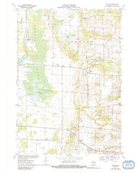
1969 Map of Polonia
USGS Topo · Published 1991About this map
The glacial landscape of central Wisconsin is defined by a mosaic of wetlands and small agricultural hamlets in this late-1960s survey. Jordan Swamp dominates the western edge, fed by the Plover River and Lost Creek, while the eastern portion transitions to the rolling terrain around the Tomorrow River. These rural communities are centered on local institutions such as Sacred Heart Sch and the community of Polonia. To the south, the industrial and transport corridor follows the Soo Line railroad, connecting the settlements of Stockton and Custer. The map reveals a high density of specialized infrastructure including a Radio Tower, numerous Gravel Pits, and a sprawling network of irrigation or municipal wells, reflecting the region's reliance on both groundwater and geological extraction. Small crossroads like Ellis serve as anchors for local life, featuring both the St Martin Ch and Edison Sch.
Find a feature on this map
31 named features on this map. Tap any name to fly to it.
Don’t see what you’re looking for? This feature index may not catch every label — zoom into the map to look around manually.
Map Details
Editions of this 1969 Polonia Map
2 editions found
Other maps of this area

1955 · Rosholt
USGS Topo · 1:48,000

1955 · Green Bay
USGS Topo · 1:250,000

1956 · Stevens Point
USGS Topo · 1:48,000

1957 · Amherst
USGS Topo · 1:48,000

1957 · Whiting
USGS Topo · 1:48,000

1969 · Rosholt
USGS Topo · 1:24,000

1969 · New Hope
USGS Topo · 1:24,000

1969 · Arnott
USGS Topo · 1:24,000

1969 · Rosholt NW
USGS Topo · 1:24,000
1969 · Polonia
USGS Topo · 1:24,000