
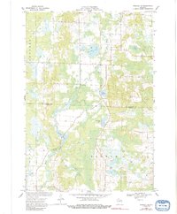
1969 Map of Rosholt NW
USGS Topo · Published 1972About this map
The Plover River winds through this central Wisconsin landscape at the border of Marathon Co and Portage Co, anchoring a region defined by its numerous glacial water bodies. The settlement of Shantytown serves as a small hub near the center of the sheet, situated near a Fish Hatchery and several distinctive lakes, including Glisezinski Lake and the oddly named Bentley Pond. Further north, Big Bass Lake and Little Bass Lake sit within the township of Bevent, while Swamp Lake marks the northeastern corner. The presence of multiple Gravel Pits suggests the local importance of aggregate mining during this era. This survey provides a look at the rural character of Guenther and Sharon before modern land-use changes altered the shorelines and surrounding woodlots.
Find a feature on this map
18 named features on this map. Tap any name to fly to it.
Don’t see what you’re looking for? This feature index may not catch every label — zoom into the map to look around manually.
Map Details
Editions of this 1969 Rosholt NW Map
2 editions found
Other maps of this area

1899 · Wausau
USGS Topo · 1:125,000

1902 · Wausau
USGS Topo · 1:125,000

1953 · Wausau
USGS Topo · 1:48,000

1953 · Hatley
USGS Topo · 1:48,000

1955 · Rosholt
USGS Topo · 1:48,000

1955 · Green Bay
USGS Topo · 1:250,000

1956 · Stevens Point
USGS Topo · 1:48,000

1963 · Wausau
USGS Topo · 1:62,500

1964 · Hatley
USGS Topo · 1:62,500

1969 · Rosholt
USGS Topo · 1:24,000