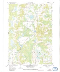
1969 Map of Rosholt NW
USGS Topo · Published 1991About this map
The Plover River winds through this central Wisconsin landscape, defining a wetland-rich corridor as it crosses from Guenther in Marathon County into Sharon in Portage County. This 1969 survey captures the rural character of the region, anchored by the small settlement of Shantytown and a nearby Fish Hatchery. The terrain is marked by numerous glacial water bodies, including Big Bass Lake, Little Bass Lake, and Glisezinski Lake, often surrounded by marshes and smaller features like Bentley Pond. Human activity in the late 1960s is evidenced by several Gravel Pit locations and a network of rural roads connecting scattered farmsteads and wells. The map provides a detailed view of the natural hydrology, from the headwaters of Lost Creek to the secluded Twin Lakes, offering a clear look at the area's geography before significant modern development altered these traditional drainage patterns.
Find a feature on this map
17 named features on this map. Tap any name to fly to it.
Don’t see what you’re looking for? This feature index may not catch every label — zoom into the map to look around manually.
Map Details
Editions of this 1969 Rosholt NW Map
2 editions found

Other maps of this area

1899 · Wausau
USGS Topo · 1:125,000

1902 · Wausau
USGS Topo · 1:125,000

1953 · Wausau
USGS Topo · 1:48,000

1953 · Hatley
USGS Topo · 1:48,000

1955 · Rosholt
USGS Topo · 1:48,000

1955 · Green Bay
USGS Topo · 1:250,000

1956 · Stevens Point
USGS Topo · 1:48,000

1963 · Wausau
USGS Topo · 1:62,500

1964 · Hatley
USGS Topo · 1:62,500

1969 · Rosholt
USGS Topo · 1:24,000