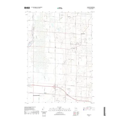
2018 Map of Polonia
USGS Topo · Published 2018About this map
The Plover River and its accompanying Jordan Swamp dominate the western landscape of this Portage County region, creating a distinct natural boundary near the eastern edge of Stevens Point. The map illustrates a rural settlement pattern defined by small crossroads communities such as Polonia, Ellis, and Custer. While Stevens Point shows signs of residential expansion with streets like Regent St and Algoma St, the surrounding townships remain characterized by agricultural parcels and scattered glacial lakes. The drainage of the Tomorrow River in the northeast and water bodies like Oesterle Lake and Bakers Lake dictate the winding path of local routes. This 2018 survey captures the transition from the city's suburban fringe into the dense network of county roads and family-named lanes that define the central Wisconsin countryside.
Find a feature on this map
82 named features on this map. Tap any name to fly to it.
Don’t see what you’re looking for? This feature index may not catch every label — zoom into the map to look around manually.
Map Details
Editions of this 2018 Polonia Map
This is the sole edition of this map. No revisions or reprints were ever made.
Other maps of this area

1955 · Rosholt
USGS Topo · 1:48,000

1955 · Green Bay
USGS Topo · 1:250,000

1956 · Stevens Point
USGS Topo · 1:48,000

1957 · Amherst
USGS Topo · 1:48,000

1957 · Whiting
USGS Topo · 1:48,000

1969 · Rosholt
USGS Topo · 1:24,000

1969 · New Hope
USGS Topo · 1:24,000

1969 · Arnott
USGS Topo · 1:24,000

1969 · Rosholt NW
USGS Topo · 1:24,000
1969 · Polonia
USGS Topo · 1:24,000