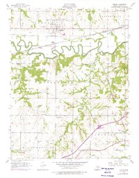
1956 Map of Pomona
USGS Topo · Published 1975About this map
The Marais Des Cygnes River meanders across this Franklin County landscape, creating a dramatic series of tight oxbow loops between the communities of Pomona and Homewood. During this mid-century period, the regional economy was defined by the intersection of rail lines and rural agricultural life, with the Atchison Topeka and Santa Fe and the Missouri Pacific railroads cutting through the northern half of the territory.
Find a feature on this map
31 named features on this map. Tap any name to fly to it.
Don’t see what you’re looking for? This feature index may not catch every label — zoom into the map to look around manually.
Map Details
Editions of this 1956 Pomona Map
2 editions found

Other maps of this area

1885 · Burlington
USGS Topo · 1:125,000

1885 · Garnett
USGS Topo · 1:125,000

1885 · Lawrence
USGS Topo · 1:125,000

1889 · Burlingame
USGS Topo · 1:125,000

1889 · Lawrence
USGS Topo · 1:125,000

1894 · Garnett
USGS Topo · 1:125,000

1894 · Burlingame
USGS Topo · 1:125,000

1894 · Burlington
USGS Topo · 1:125,000

1947 · Lawrence
USGS Topo · 1:250,000

1950 · Lawrence
USGS Topo · 1:250,000