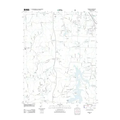
2012 Map of Pomona
USGS Topo · Published 2012About this map
Pomona and Etherton anchor the southern and central portions of this Jackson County landscape, characterized by a complex network of ridges and hollows such as Cave Valley and Wolfden Hollow. The eastern edge is dominated by the sprawling waters of Cedar Lake, while the topography to the west is marked by Rocky Hollow and the Pomona Natural Bridge Picnic Area. This area exhibits a deep-rooted burial history with numerous family and community plots including Mount Carbon Cem, Bostick Cem, and Hiller-Crab Orchard Cem. The presence of the Jackson County Farm near the center of the quadrangle suggests a history of local agricultural administration. Roadways like Potato Patch Holler Rd and Natural Bridge Rd provide clues to the local geography and historical vernacular of the region.
Find a feature on this map
129 named features on this map. Tap any name to fly to it.
Don’t see what you’re looking for? This feature index may not catch every label — zoom into the map to look around manually.
Map Details
Editions of this 2012 Pomona Map
This is the sole edition of this map. No revisions or reprints were ever made.
Other maps of this area

1910 · Herrin
USGS Topo · 1:62,500

1910 · Murphysboro
USGS Topo · 1:62,500

1922 · Carbondale
USGS Topo · 1:62,500

1924 · Alto Pass
USGS Topo · 1:62,500

1936 · Herrin
USGS Topo · 1:62,500

1938 · Murphysboro
USGS Topo · 1:62,500

1941 · Carbondale
USGS Topo · 1:62,500

1947 · Alto Pass
USGS Topo · 1:62,500

1947 · Gorham
USGS Topo · 1:24,000
1947 · Wolf Lake
USGS Topo · 1:24,000