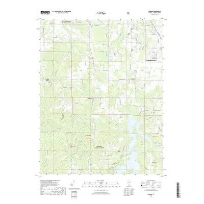
2018 Map of Pomona
USGS Topo · Published 2018About this map
The Pomona Natural Bridge stands as a prominent geological landmark within the rugged southern Illinois landscape, which is heavily defined by the winding reaches of the Shawnee National Forest. This 2018 survey documents a region where agricultural land and dense woodland meet, centered around the rural communities of Etherton, Pomona, and the outskirts of Carbondale. The map illustrates a high density of burial sites that provide a roadmap for local family histories, including Mount Carbon Cem, Hiller-Crab Orchard Cem, and the Union Hills Cem. Water plays a central role in the terrain's character, from the broad expanse of Cedar Lake to the intricate drainages of Cave Valley and Cove Hollow. The presence of established settlements like Poplar Ridge alongside these natural features shows the enduring intersection of human residency and the protected forest environment.
Find a feature on this map
99 named features on this map. Tap any name to fly to it.
Don’t see what you’re looking for? This feature index may not catch every label — zoom into the map to look around manually.
Map Details
Editions of this 2018 Pomona Map
This is the sole edition of this map. No revisions or reprints were ever made.
Other maps of this area

1910 · Herrin
USGS Topo · 1:62,500

1910 · Murphysboro
USGS Topo · 1:62,500

1922 · Carbondale
USGS Topo · 1:62,500

1924 · Alto Pass
USGS Topo · 1:62,500

1936 · Herrin
USGS Topo · 1:62,500

1938 · Murphysboro
USGS Topo · 1:62,500

1941 · Carbondale
USGS Topo · 1:62,500

1947 · Alto Pass
USGS Topo · 1:62,500

1947 · Gorham
USGS Topo · 1:24,000
1947 · Wolf Lake
USGS Topo · 1:24,000