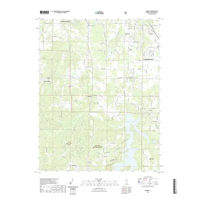
2021 Map of Pomona
USGS Topo · Published 2021About this map
The Shawnee National Forest dominates the southern reaches of this Jackson County map, where the terrain is defined by the steep bluffs and valleys of Dutch Ridge and Cove Hollow. A significant geological landmark, the Pomona Natural Bridge, sits just north of the community of Pomona, illustrating the erosional forces that shaped this landscape. Settlement patterns follow the higher ground between water bodies like Cedar Lake and Carbon Lake, with several long-established rural cemeteries such as Dutch Ridge Cem and Etherton Cem serving as focal points for local genealogy.
Find a feature on this map
111 named features on this map. Tap any name to fly to it.
Don’t see what you’re looking for? This feature index may not catch every label — zoom into the map to look around manually.
Map Details
Editions of this 2021 Pomona Map
This is the sole edition of this map. No revisions or reprints were ever made.
Other maps of this area

1910 · Herrin
USGS Topo · 1:62,500

1910 · Murphysboro
USGS Topo · 1:62,500

1922 · Carbondale
USGS Topo · 1:62,500

1924 · Alto Pass
USGS Topo · 1:62,500

1936 · Herrin
USGS Topo · 1:62,500

1938 · Murphysboro
USGS Topo · 1:62,500

1941 · Carbondale
USGS Topo · 1:62,500

1947 · Alto Pass
USGS Topo · 1:62,500

1947 · Gorham
USGS Topo · 1:24,000
1947 · Wolf Lake
USGS Topo · 1:24,000