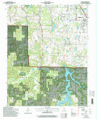
1996 Map of Pomona
USGS Topo · Published 1998About this map
Cedar Lake dominates the southern landscape of this mid-1990s Jackson County survey, its irregular shoreline reaching into the deep drainages of the Shawnee National Forest. The map documents a transition from the agricultural plateaus around Etherton to the complex topography of Dutch Ridge and Poplar Ridge. In the southwest corner, the Pomona Natural Bridge stands as a distinct geological landmark near the small settlement of Pomona, where the Cave Creek Valley meets the lower elevations.
Find a feature on this map
57 named features on this map. Tap any name to fly to it.
Don’t see what you’re looking for? This feature index may not catch every label — zoom into the map to look around manually.
Map Details
Editions of this 1996 Pomona Map
This is the sole edition of this map. No revisions or reprints were ever made.
Other maps of this area

1910 · Herrin
USGS Topo · 1:62,500

1910 · Murphysboro
USGS Topo · 1:62,500

1922 · Carbondale
USGS Topo · 1:62,500

1924 · Alto Pass
USGS Topo · 1:62,500

1936 · Herrin
USGS Topo · 1:62,500

1938 · Murphysboro
USGS Topo · 1:62,500

1941 · Carbondale
USGS Topo · 1:62,500

1947 · Alto Pass
USGS Topo · 1:62,500

1947 · Gorham
USGS Topo · 1:24,000
1947 · Wolf Lake
USGS Topo · 1:24,000