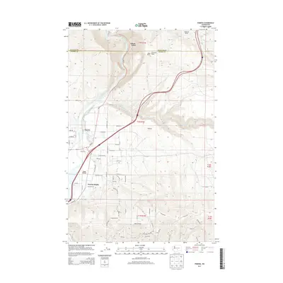
2013 Map of Pomona
USGS Topo · Published 2013About this map
The Yakima River carves through a landscape of dramatic elevation changes and agricultural development north of the Yakima area. This 2013 survey documents the transition from the high, dry elevations of Umtanum Ridge and Selah Butte in the north to the more densely settled valley floors. Community life centers on locations like East Selah, Pomona, and Pomona Heights, where a complex grid of rural roads such as Wise Acre Rd and Pomona Heights Rd serves local residents. A notable cultural landmark is the Salamonia Grange, reflecting the area's agricultural heritage. The southern portion of the map is defined by the east-west orientation of Yakima Ridge, which rises above the expanding residential developments and agricultural holdings like El Kay Farms. Local industry and transit are represented by Hillside Siding along the northern rail corridor.
Find a feature on this map
63 named features on this map. Tap any name to fly to it.
Don’t see what you’re looking for? This feature index may not catch every label — zoom into the map to look around manually.
Map Details
Editions of this 2013 Pomona Map
This is the sole edition of this map. No revisions or reprints were ever made.
Other maps of this area

1899 · Ellensburg
USGS Topo · 1:125,000

1901 · Ellensburg
USGS Topo · 1:125,000

1936 · Yakima East
USGS Topo · 1:48,000

1938 · Badger Pocket
USGS Topo · 1:48,000

1941 · Yakima East
USGS Topo · 1:62,500

1943 · Badger Pocket
USGS Topo · 1:62,500

1950 · Yakima
USGS Topo · 1:250,000

1953 · Pomona
USGS Topo · 1:24,000
1953 · Badger Gap
USGS Topo · 1:24,000

1953 · Elephant Mountain
USGS Topo · 1:24,000