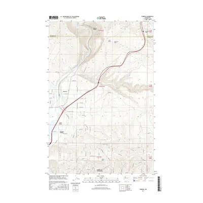
2017 Map of Pomona
USGS Topo · Published 2017About this map
The Yakima River carves through a landscape of prominent basalt ridges and developing residential communities north of Yakima. This 2017 survey highlights the transition from the river valley's riparian corridors to the elevated plateaus of Selah Butte and Umtanum Ridge. The map details the expansion of Terrace Heights and the agricultural-to-residential shift in areas like Pomona Heights and East Selah. Small rail-oriented settlements like Hillside Siding and Pomona reflect the area's logistical history, while the broader topography is defined by the massive Yakima Ridge. Significant water features including Selah Creek and Wenas Creek are captured as they feed into the primary river system, alongside a complex network of local roads such as Buffalo Rd and Corriedale Rd that segment the foothills.
Find a feature on this map
53 named features on this map. Tap any name to fly to it.
Don’t see what you’re looking for? This feature index may not catch every label — zoom into the map to look around manually.
Map Details
Editions of this 2017 Pomona Map
This is the sole edition of this map. No revisions or reprints were ever made.
Other maps of this area

1899 · Ellensburg
USGS Topo · 1:125,000

1901 · Ellensburg
USGS Topo · 1:125,000

1936 · Yakima East
USGS Topo · 1:48,000

1938 · Badger Pocket
USGS Topo · 1:48,000

1941 · Yakima East
USGS Topo · 1:62,500

1943 · Badger Pocket
USGS Topo · 1:62,500

1950 · Yakima
USGS Topo · 1:250,000

1953 · Pomona
USGS Topo · 1:24,000
1953 · Badger Gap
USGS Topo · 1:24,000

1953 · Elephant Mountain
USGS Topo · 1:24,000