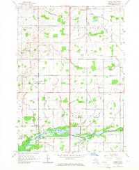
1965 Map of Pompeii
USGS Topo · Published 1966About this map
Maple River winds through the southern reaches of this mid-Michigan landscape, creating a wetland corridor protected as a State Game Area by the mid-1960s. The region is defined by its rectilinear agricultural grid, with long stretches of Grand Trunk Road and State Road connecting small rural hubs. The settlement of Pompeii serves as a central point of interest, while the northern village of North Star (Northstar PO) marks a site of early commerce and mail service. This survey provides a clear view of the communal infrastructure that sustained these farming townships, from the Townhall and Washington Center Sch to the East Washington Ch and Bethel Chapel. Family-named landmarks like Barnes Cem and Collier Cem offer valuable points for genealogical research, identifying the resting places and landholdings of early area residents within the townships of Newark, North Star, Fulton, and Washington.
Find a feature on this map
54 named features on this map. Tap any name to fly to it.
Don’t see what you’re looking for? This feature index may not catch every label — zoom into the map to look around manually.
Map Details
Editions of this 1965 Pompeii Map
This is the sole edition of this map. No revisions or reprints were ever made.
Other maps of this area

1918 · Elsie
USGS Topo · 1:62,500

1918 · Perrinton
USGS Topo · 1:62,500

1934 · Merrill
USGS Topo · 1:62,500

1935 · Alma
USGS Topo · 1:62,500

1937 · Merrill
USGS Topo · 1:62,500

1938 · Alma
USGS Topo · 1:62,500

1943 · Perrinton
USGS Topo · 1:62,500

1943 · Elsie
USGS Topo · 1:62,500

1954 · Midland
USGS Topo · 1:250,000

1958 · Midland
USGS Topo · 1:250,000
Featured Places
- North Star, North Star Township
- Bridgeville, Washington Township
- Newark Township, MI
- North Star Township, MI
- Fulton Township, MI