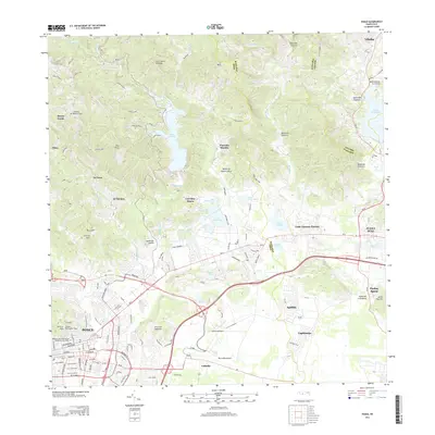
2013 Map of Ponce
USGS Topo · Published 2013About this map
The Ponce urban center and its sprawling surroundings are meticulously detailed in this early 21st-century landscape, where industrial sites like Central Mercedita stand near the Mercedita Airport. Historically significant locations are prominent, including the Panteón Nacional Román Baldorioty de Castro and the Vigia Observation Tower atop Cerro el Vigia. The northern terrain rises into the foothills of the Island of Puerto Rico, marked by peaks such as Pico Pinto and Cerro Santo Domingo. A complex hydrological network is visible, dominated by the Rio Cerrillos and Lago Cerrillos, which serve the agricultural and residential needs of nearby communities like Cerrillos Hoyos and Luis Llorens Torres. Modern transportation routes like PR-10 and Ave Las Americas connect these diverse sectors, from the residential clusters of Aguilita to the coastal plains of Capitanejo.
Find a feature on this map
68 named features on this map. Tap any name to fly to it.
Don’t see what you’re looking for? This feature index may not catch every label — zoom into the map to look around manually.
Map Details
Editions of this 2013 Ponce Map
This is the sole edition of this map. No revisions or reprints were ever made.
Other maps of this area

1944 · Santa Isabel
USGS Topo · 1:30,000

1945 · Playa De Ponce
USGS Topo · 1:30,000

1945 · Ponce
USGS Topo · 1:30,000

1945 · Rio Descalabrado
USGS Topo · 1:30,000

1946 · Punta Cuchara
USGS Topo · 1:30,000

1946 · Jayuya
USGS Topo · 1:30,000

1946 · Orocovis
USGS Topo · 1:30,000

1946 · Penuelas
USGS Topo · 1:30,000

1946 · Adjuntas
USGS Topo · 1:30,000

1947 · Ponce NE
USGS Topo · 1:10,000