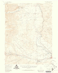
1956 Map of Poncha Springs
USGS Topo · Published 1959About this map
The Arkansas River valley serves as the central corridor for this mid-century survey, anchoring a network of small settlements and industrial markers. To the southeast, the city of Salida and nearby Smeltertown represent the region's urban and industrial core, while higher-elevation communities like Maysville and Poncha Springs sit at the transitions into the surrounding peaks. The Denver and Rio Grande Western Railroad tracks follow the river's path, highlighting the vital transport links that sustained these mountain valley towns. Rural infrastructure is well-documented, including several community hubs like Centerville Sch and the Centerville Cem. Higher in the terrain, the San Isabel National Forest boundary marks the shift from irrigated lands like Missouri Park and Adobe Park toward the high summits of Mt Princeton and Mount Antero.
Find a feature on this map
80 named features on this map. Tap any name to fly to it.
Don’t see what you’re looking for? This feature index may not catch every label — zoom into the map to look around manually.
Map Details
Editions of this 1956 Poncha Springs Map
6 editions found

Other maps of this area

1940 · Garfield
USGS Topo · 1:62,500

1945 · Garfield
USGS Topo · 1:62,500

1954 · Pueblo
USGS Topo · 1:250,000

1955 · Buena Vista
USGS Topo · 1:62,500

1955 · Mount Harvard
USGS Topo · 1:62,500

1956 · Cameron Mountain
USGS Topo · 1:62,500

1956 · Poncha Springs
USGS Topo · 1:62,500

1956 · Montrose
USGS Topo · 1:250,000

1957 · Pueblo
USGS Topo · 1:250,000

1958 · Pueblo
USGS Topo · 1:250,000